

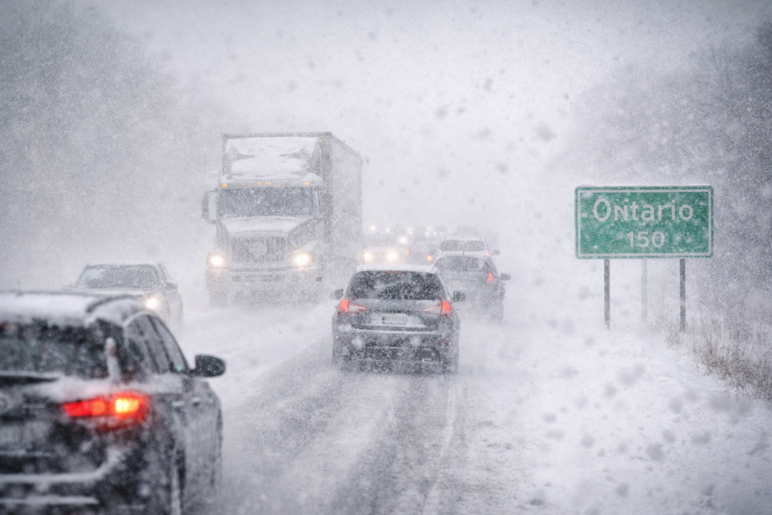
If you’ve ever driven along Highway 401 in winter and watched the world disappear in a wall of white, you already know what snow squalls feel like. One moment the road is clear. The next moment visibility drops to almost nothing. Wind pushes snow sideways across the highway. Headlights blur into glowing dots.
Snow squalls are one of the most dramatic and unpredictable weather patterns in the province. They can turn a normal winter afternoon into a serious driving challenge in just minutes. And because Ontario sits beside the Great Lakes, these bursts of heavy snow show up here more often than in many other parts of Canada.
Let’s walk through what snow squalls are, why they happen so often in Ontario, and what residents should keep in mind when they appear.
What exactly is a snow squall?
A snow squall is a sudden burst of heavy snowfall combined with strong winds and sharply reduced visibility. Unlike large winter storms that stretch across entire regions, squalls are narrow and intense. They often affect small areas while nearby towns see only light snow—or even sunshine.
Think of it like a snow shower with muscle.
Snow squalls move quickly and can develop within minutes. Meteorologists often compare them to summer thunderstorms, except instead of rain and lightning, they bring heavy snow and blowing wind.
| Weather Feature | Description |
|---|---|
| Snowfall rate | Heavy bursts that can accumulate quickly |
| Visibility | Often drops to near zero |
| Wind | Strong gusts that blow snow across roads |
| Duration | Usually short but intense |
The tricky part is their speed. By the time drivers realize they’re entering a squall, they may already be inside it.
Why Ontario sees so many snow squalls
The answer sits right on the map: the Great Lakes.
Ontario’s lakes—Superior, Huron, Erie, and Ontario—play a huge role in shaping winter weather. When cold Arctic air moves across the relatively warmer lake water, the atmosphere becomes unstable. Moisture rises from the lakes and forms narrow bands of heavy snowfall.
This process is called lake-effect snow.
And when those snow bands intensify, they become snow squalls.
The areas most affected often lie downwind of the lakes. Places like Barrie, Owen Sound, London, and parts of eastern Ontario see frequent squall activity during the winter months.
- Cold air moves across warmer lake water
- Moisture rises rapidly into the atmosphere
- Snow bands form downwind of the lakes
- Localized bursts of intense snowfall develop
That’s the basic recipe. Add wind and temperature shifts, and conditions can change very quickly.
The driving danger: visibility
Ask Ontario drivers what makes snow squalls dangerous and they’ll usually answer with one word: visibility.
When a squall hits, visibility can drop from several kilometres to just a few metres almost instantly. Drivers call this a “whiteout.”
Imagine cruising along a highway at normal speed. Suddenly the road ahead fades. Snow blows sideways across your windshield. Tail lights ahead become faint red shadows.
That sudden shift catches people off guard.
And unfortunately, snow squalls are often linked to multi-vehicle collisions because drivers cannot see far enough ahead to react safely.
| Road Condition | Driver Experience |
|---|---|
| Clear road | Normal visibility and traffic flow |
| Entering a squall | Rapidly decreasing visibility |
| Inside a whiteout | Drivers may see only a few metres ahead |
| After the squall | Conditions may improve quickly |
The sudden nature of these changes is what makes squalls particularly risky.
Highways where snow squalls hit hardest
Some Ontario highways are especially known for snow squall conditions. These routes run through lake-effect snow zones where winter weather can intensify quickly.
Drivers in the province know these corridors well.
- Highway 401 near London and Kingston
- Highway 400 north of Toronto toward Barrie
- Highway 21 along Lake Huron
- Highway 11 in northern Ontario
When squalls develop in these areas, transportation authorities sometimes issue snow squall warnings or travel advisories.
These warnings exist for a reason. They signal that conditions can deteriorate extremely fast.
What meteorologists watch when forecasting squalls
Forecasting snow squalls requires close attention to temperature differences between lake water and incoming air masses.
Meteorologists also monitor wind direction. Even a small change in wind can shift a snow band several kilometres east or west.
This means a town may be buried under heavy snowfall while another community only a short drive away sees almost nothing.
That unpredictability makes squalls fascinating—and challenging—to forecast.
Weather radar helps track these narrow bands as they move inland. Meteorologists can see the snow forming over the lakes and watch where it travels.
Still, predicting the exact location of the heaviest snowfall is not always easy.
How Ontario drivers can stay safer
Snow squalls are part of winter life in Ontario, but drivers can reduce risks by adjusting their behaviour when conditions change.
The most important habit? Slow down.
It sounds simple, but speed plays a huge role in winter accidents. When visibility drops suddenly, drivers need extra time to react.
- Reduce speed when snow begins to fall heavily
- Increase distance between vehicles
- Turn on headlights for better visibility
- Avoid sudden braking or lane changes
- If visibility becomes zero, pull over safely
Winter driving requires patience. Snow squalls reward drivers who stay calm and cautious.
Life in a province built for winter
Ontario residents are no strangers to winter weather. From Ottawa to Thunder Bay, snowstorms and freezing temperatures are part of the seasonal rhythm.
But snow squalls still stand out because of their intensity.
One moment you might see blue sky above a frozen lake. Ten minutes later, thick snow clouds roll inland and blanket the road. The shift can feel dramatic, almost cinematic.
Yet for people who live here, it’s simply another part of the winter landscape.
Kids still head out for hockey practice. Commuters still make their way to work. And snowplows roll through the night keeping roads open.
FAQ
What causes snow squalls in Ontario?
Snow squalls usually form when cold air moves across the warmer waters of the Great Lakes, creating intense bands of lake-effect snow.
Are snow squalls the same as snowstorms?
No. Snowstorms cover large regions and last longer. Snow squalls are narrow, fast-moving bursts of heavy snow.
Why are snow squalls dangerous for drivers?
Visibility can drop suddenly to near zero, making it difficult for drivers to see other vehicles or road conditions.
Which areas in Ontario see the most squalls?
Communities near the Great Lakes, such as Barrie, London, and parts of eastern Ontario, experience frequent lake-effect snow.
How long do snow squalls usually last?
They can last from a few minutes to several hours depending on weather conditions.
What should drivers do in a whiteout?
Slow down, increase following distance, and if necessary pull off the road safely until visibility improves.
Do snow squalls happen every winter?
Yes. They are a common winter weather pattern in Ontario, especially from late fall through early spring.
Conclusion
Snow squalls are one of Ontario’s most dramatic winter weather events. They arrive suddenly, move quickly, and can turn a calm winter drive into a challenging situation within minutes.
But they are also part of the province’s natural winter rhythm, shaped by the powerful influence of the Great Lakes.
Understanding how squalls form—and how to react when they appear—helps drivers stay safer on Ontario’s busy winter roads.
And as every experienced local knows, winter driving here always comes with one simple rule.
Expect the unexpected.